Germs are sort of like bacteria. Germs can be good and bad. Good germs fight bad germs and bad germs like virus, cold, and flu germs fight good germs. There is a five second rule – if you drop a piece of food on the ground for more than five seconds you should not eat it. If less than 5 seconds if you want you can eat it. The sponge we used to clean our dishes had millions of germs on it every time you use it to clean plates the germs from the plate get on the sponge. To avoid that throw away the sponge every week/few days and use a different one for the next week/few days.
Dirty pan
Germs spread by touching other people for a long time (more than five seconds). Fist bumps and high fives are okay, but you should do a fist bump instead of high five. They don’t spread as many germs as touching some one. You can have family rules to keep your family safe from most bad germs.
My dad and sister doing a high fiveThe author in action
Dozens of people throughout San Diego had their lifestyle influenced by the coronavirus, a sickness that is leaving destruction in its wake at it moves rapidly around the world. People are going into chaos when the coronavirus hits their country, state, city, or community. New rules are popping up all over countries to keep people safe. The coronavirus epidemic is becoming a world wide struggle. New things that are happening, such as the closing of shops, are going on because people don’t need the things inside the shop, plus when people gather, like to shop or play, germs get on to other people, causing them to become sick. The coronavirus is a contagious disease, which means that if someone else gets the germ that person will get the same sickness. Therefore, shops are closing. Rules such as only ten people in the supermarket at a time are being made world wide to prevent the spreading of germs. Supermarkets are pretty much the only kind of stores open nowadays. Schools have been closed so me and my brother Ambrose have been doing home school to keep up on our learning progress. I can tell you that these changes have been affecting people I know, such as my classmates, teacher (Mrs. Bobier), and my around the block friend Sophie have all had to make many changes in order to adjust to this new lifestyle. Public parks (or at least their parking lots) have been closing due to these changes.
Ambrose Anderson riding his bike
My morning routine has changed as well. Instead of going to school in the morning me and my dad have been teaching Ambrose to ride his bike and we’ve been going on rides throughout San Diego (although he complains about hills a lot). Today we rode to South Park and back. My dad spray painted Ambrose’s bike red and black. I have heard that in Italy people are not allowed to leave their house except to get food. My family bikes every morning to get fresh air and exercise because those two things are very important to maintaining a healthy lifestyle, which is important to have due to circumstances beyond our control – the coronavirus.
Eva Anderson pulls Ambrose and Oliver AndersonThe author riding on her bike
Although North Park’s “Busy Corner” lies a block north, the intersection of North Park Way and 30th Street is a popular crossing for pedestrians in the neighborhood. In the heart of North Park, this intersection hosts Waypoint Public, Pigment, the North Park Parking Garage, and North Park Family Dentistry with many more businesses and residences nearby. It is also an intersection that needs improvement to increase safety and convenience for residents and visitors to North Park.
Today my neighbor recounted being hit by a car driver at this intersection last week while she was pushing a stroller and walking with her seven-year-old. The driver did not yield when making a left turn and did not use a blinker to indicate the left turn. She plowed into the group of three in broad daylight. If you walk this intersection you may have had close calls with drivers as I have on a number of occasions. We need to do much more to make our neighborhoods safer – motor vehicle crashes are the top cause of death for American children and adolescents ages 1 to 19.
For this specific intersection here are a number of improvements we can make. (The following could be applied to many areas across the city as well and hopefully some, like LPI, become the default treatment rather than reactive to areas with injuries.)
Sync pedestrian signals. Currently the east-west and north-south crossing signals do not sync – if you push the button on the east side only that side will give a “Walk” signal on green. These indicators should be synced for both sides of the street.
Automate pedestrian signals with minimum crossing times. In addition to pushing the pedestrian walk request (aka “beg buttons”) the pedestrian walk symbol should automatically be triggered and illuminated for the minimum crossing time when a vehicle triggers a light change.
Add a Leading Pedestrian Interval (LPI) in addition to automatic minimum crossing time signal. An LPI gives pedestrians a 3-7 second head start when crossing an intersection. NACTO notes that LPIs “have been shown to reduce pedestrian-vehicle collisions as much as 60% at treated intersections”. You may have seen LPIs in action at 6th Avenue and Laurel Street or other locations.
Add “Yield to Pedestrian on Turns” signs. A simple reminder to look around when driving and be aware.
Add curb bulbouts to the intersection corners to reduce the road width (and consequently road speeds). The image below is the current intersection with red added for potential curb bumpouts to reduce the road width and in which plants and trees could be added or benches to sit. The bulbouts would also reduce the roll-through turns that are common enough to be known as “California Stops”. The yellow portions are for potential additional parking spaces to accompany the bulbouts. (I don’t favor more auto parking in the area as there are better uses for our limited public land but seems to be a way to help get safety improvements done since many like a free lunch.)
6. Add red light cameras to penalize bad actors (after remaking them legal in San Diego). In 2013 San Diego got rid of red light cameras that were used to penalize those breaking laws at intersections. Cameras are cheap and effective ways to enforce laws like speeding, running red lights, etc. and would be ideal for areas like this intersection where common law-breaking by drivers has more severe repercussions due to the high number of humans nearby.
7. Lower speed limit to 20 MPH. Lower speeds help to avoid collisions and reduce the harm when collisions occur. This article has a great interactive chart showing the relative fatality risk at various speeds.
If you’re interested in helping make this intersection better in the ways noted above (or your own) you can help by contacting our City Councilmember, Chris Ward at christopherward@sandiego.gov and the Council Office Rep for North Park, Tyler Renner – trenner@sandiego.gov.
Taking a moment to send a message as simple as “Please make the intersection at 30th and North Park Way safer. Our family walks there often. Thank you.” are great and really help to make improvements on the ground reality.
[Related note: Thank you to all that voiced support for a new crosswalk at Jefferson Elementary – located 3 blocks directly west of the intersection highlighted in this post. Mr. Renner informed me this is scheduled to be installed in 2019 as part of the new Mini-Park in North Park behind the Observatory.]
For context here are a few photos of the intersection I took today, 1/5/2019.
Let’s make the neighborhood a bit safer and more enjoyable for all
North Park has had a number of crosswalks installed in recent months, including some with push-button flashing lights as you can now see at the corners of 30th Street and Myrtle as well as 30th Street and Polk, as well as other locations. It has seemed to make a positive impact on the likelihood of drivers that yield to pedestrians at these intersections and hopefully an overall greater awareness for those walking in the area.
This post is to request a new painted crosswalk on the south portion (east-west crosswalk) of the intersection of North Park Way and Utah Street, in front of Jefferson Elementary. This intersection is just outside the front doors of the school and this three-direction intersection has a stop sign for each direction of oncoming traffic. There are currently painted crosswalks on the other two crossings at the intersection but just a “No Ped Crossing” sign for the third.
This aerial image shows the existing crosswalks to / from the Jefferson Elementary block in Yellow and the requested additional crosswalk in Red.
With all vehicles already needing to stop at this intersection it seems natural to include a painted crosswalk for pedestrians. Especially given that the school provides services for children from preschool through fifth grade it seems even more needed to have visible markings and crossings to ensure drivers are aware of the hundreds of small children in the area.
Many parents and children walk to the school from the south and east directions, either from residences or from parking in the neighborhood. Another marked crossing option would make the journey to school quicker, safer, and more convenient for all. (And outside of school hours for anyone walking in the neighborhood.)
Below is the current status of this crossing. Hopefully we can make this small improvement soon, for the use of students and the community at large.
If you’d like to help make this crosswalk a reality please reach out to the San Diego District 3 Councilmember, Chris Ward, at the following email addresses and simply voice your support. A message as simple as “Crosswalks at Jefferson needed and I support. Thank you.” are great.
Awhile back I received a data set of all the Code 415N calls to San Diego Police Department for all properties in San Diego for a one-year period, 10/1/2014 – 9/30/2015. I believe 415N is the police department code for Disturbing The Peace. The data is for all property types, not only short-term rental properties. During the short-term rental debates there has been quite a bit of discussion about the crime and safety impacts that short-term rentals have on communities so it would seem a decent place to look for elevated impacts in areas with more short-term rental units.
I took the information and did some high level analysis of the complaint calls – the data file is included here and the notes / calculations I added are at the top right of attached file.
[Note: I didn’t have the TOT addresses to match to the 415N info (and the 415N info doesn’t have zip so I’m not sure how you match it unless they use the exact same address typing for both sets of data. I didn’t take a stab at it since it’s above my skill level to break that down. I’m also unsure of the completeness of TOT addresses since Airbnb now handles those remittances for hosts, so many are likely not registered with the City Treasurer.]
Some points I thought might be relevant to the ongoing discussion:
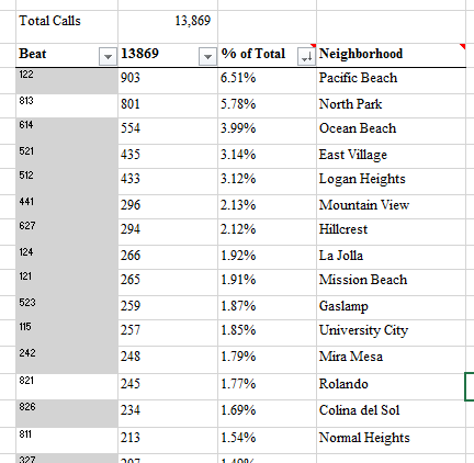
Total calls in past year = 13,869. With city population of 1.381 million that comes out to 1% of the population making 1 call per year. I don’t know what a “good” nuisance reporting rate is, but if 1 of 100 people are calling once per year that seems pretty low.
Average calls per district – with 9 districts the total number of complaints comes out to 4.22 calls per day. When thinking about enforcement needs, this seems a relevant point. I would think 1 hire per district could handle 4.22 calls per day, maybe 10 or 20 (I don’t know). At least a good point for talking about what resources are needed to handle complaint volume.
Police beat areas with most 415N calls
Complaints by neighborhood – the data doesn’t match to exact addresses, but is useful in seeing where complaints are from by beat area and how that matches to the neighborhoods cited as being short-term rental problem spots. In the top 5 by % of complaints are: Pacific Beach (6.51%), North Park (5.78%), Ocean Beach (3.99%), East Village (3.14%), and Logan Heights (3.12%). Pacific Beach & Ocean Beach have had a lot of anti short-term rental sentiment, but not the other 3, maybe North Park if you include Burlingame. By address would be better to be more precise, but if you look at the Excel the neighborhoods that receive the most calls don’t correspond much to anti short-term rental sentiment, and I would guess correspond mostly to total population (which makes sense in general) than to perceived / actual short-term rental caused issues.
Wanted to share this information in case of interest to others. It seems a good touch point in the overall conversation so I thought worth posting.
San Diego County has been a home to refugees from all over the globe for many years. In recent years the region has likely taken in more refugees than any other region in the United States.
Refugee – a person who has been forced to leave their country in order to escape war, persecution, or natural disaster.
Per the San Diego Union-Tribune, “this region gets approximately 3,000 new refugees each year, with a striking majority hailing from restive Iraq.” In fiscal year 2009 the county took in 4,168 which has declined to 1,610 in fiscal year 2015 – I believe the 3,000 in the article is the average for the period 2009-2015. Per the same article the refugees that have settled in San Diego and formed a community here over the past 45 years have included those from:
Based on these sources San Diego has taken in more refugees than any other region in California and California has taken in more refugees than any other state in recent years. I can’t find a breakdown by county or region but based on this it seems very likely that San Diego has taken in more refugees than any other area.
If you visit City Heights in San Diego you’ll find a wide variety of refugee communities, and in other areas of the city as well. It says something about an area that takes in so many, and in which many decide to settle long-term and welcome later arrivals. I feel pride that San Diego is a place that is desirable to live in for those fleeing persecution.
There is a heated debate currently regarding refugees from Syria and who will or will not welcome them in the United States. I trust that San Diego, officially and socially, will continue to welcome refugees from all over the world. San Diego is a very safe place to live – large amounts of refugees settling here for many decades have not compromised our safety. What newly arrived refugees will do is strengthen our regional community and reaffirm that San Diego is a welcoming place to people from the world over whether refugees, visitors, investors, children, professionals, or otherwise. In time they’ll offer a helping hand to those that follow and start families, companies, non-profits, and community organizations that reinvigorate our neighborhoods. It’s ever been the story of the United States and one that San Diego will continue to follow.
That’s something that all San Diegans can be proud of. #SDlove
Road rage is defined as “violent anger caused by the stress and frustration involved in driving a motor vehicle in difficult conditions”. The term has some nice alliteration but a more fitting term would be “car rage”. Perhaps we use road rage because we don’t want to acknowledge the damage and deaths that our passionate and loving embrace of the automobile causes. Tens of thousands of deaths every year, yet rarely a headline in the paper. The deaths are in the paper, just in the small print area inside with some short explanations that will impugn the non-auto parties at every turn. Lots of mentions of crosswalks, lighting conditions, and visibility of clothing but few notes about Big Gulps, radio fiddling, use of phones, makeup application, driving history, or attention paid to road.
If you walk, or ride the bus, or ride a bicycle you don’t experience the same elevation of pulse, stress level, and anger as experienced when driving – especially at high speeds. It seems mostly confined to the experience of driving in an automobile. So perhaps we should retire “road rage” and start using “car rage”. It won’t do much for the victims but it will at least change the conversation a bit and recognize that the most aggressive parties on our roads (which includes in front of our homes, schools, and businesses) are those using motor vehicles.
There is also a definition for “bike rage” and helpfully included in the examples section are all the different attack methods of cyclists. For some reason, in the road rage entry (below) there not similarly prominent categories regarding attacks by car drivers.
Here’s the road rage entry with some bland categories. The mentions of violence included regard shootings: guns = dangerous, cars = Hello Kitty. It’s almost like we don’t take the responsibility and risk of driving a massive vehicle at high speeds seriously.
Drive safe, drive slow, drive less. Avoid car rage.
SANDAG is preparing to implement bicycle improvements to Pershing Drive in the near future, creating a safe and functional route from North Park and surrounding communities to Downtown. This is part of the $200M SANDAG bicycle corridors program which has yet to stripe a single foot of bike lane in the nearly 3 years since being announced. The first project, running through Hillcrest, gutted the most important segment – an east-west connection to North Park – at the last moment as detailed in this film by Dennis Stein.
Pershing Drive is very different from University Avenue; it lies in a park rather than popular communities. Pershing Drive is currently a fantastic bicycle connection in many ways. It runs through the middle of Balboa Park’s open space area. Heading into town it offers gorgeous views of Los Coronados islands, Coronado Bridge, and Downtown. It connects the densely populated neighborhoods of Uptown and Mid-City to Downtown. However, it is also very intimidating to bike on. The painted lanes are adjacent to high-speed roadways with speed limits of 45-50 MPH (and we all know that 5-10 above that is the likely reality). Heading into Downtown, cyclists need to cross two separate onramps to Interstate 5, while drivers are ramping up to Interstate speeds. Both onramps lie behind curving corners with limited visibility.
I’ve been writing about the dangers of biking on Pershing Drive since early 2014 and serious injuries continue to accrue.
So how do we best create a functional, safe and protected bicycle corridor on Pershing Drive? Following are a number of specific ideas for what this project should look like. We should start with context and a general guideline. This project lies in the heart of Balboa Park – it should connect with and enhance the park, not take away from it. A guideline that should lead any transport project is to put people first – and that means pedestrians first, bicycles second, public transit third, and private automobile fourth. This is the hierarchy of preference used by the City of Chicago Department of Transportation and one that San Diego should adopt.
The Pershing Drive bicycle corridor should establish a two-way bike lane and two-way walking / running path adjacent to the Balboa Park golf course on the south / east side of Pershing Drive. The entry point would be located at Redwood & 28th. By siting the path on this side of Pershing the major friction points of the I-5 onramps are avoided (which fall under CalTrans purview and would be very difficult to address). It also presents the opportunity to put those biking or jogging in a shaded and enjoyable place along the roadway.
Connect the two halves of Bird Park at the north terminus of Pershing Drive (at 28th Street) and direct traffic either east on Redwood or north on Arnold. This will add parkland and avoid much of the backup that results from the awkward and overly large intersection now present at that location.
Reduce speeds for the entirety of Pershing Drive from the current 45-50 MPH to 35 MPH maximum and 25 MPH within 1,000 feet of the terminus at either end.
Add a path for those biking, walking, or jogging along the south side of the Naval Hospital to add a connection from Golden Hill and South Park to Balboa Park, as well as a connection for those traversing the improved Pershing Drive bicycle corridor.
Create dedicated and protected space for running / walking / jogging as well as for bicycling. Pershing Drive runs through the heart of Balboa Park and the context of this project matters. We should seek to improve the park as a whole with any project lying inside it. The space for biking and jogging should be protected by a concrete barrier or other substantial method.
Reduce Pershing Drive to one travel lane in each direction. There is one through street that intersects Pershing Drive currently – Florida Drive / 26th Street (the road changes names at the intersection). Other than this street there are only entry points for service yards and parking lots at the Velodrome and the Morley Field frisbee golf course. This matters because a prominent reason for back-up on a street can be waiting for an opportunity to turn. That option is very limited on Pershing Drive, greatly reducing the need for additional traffic lanes.
Establish trees on both sides of Pershing Drive as protective barriers for the bicycle lanes (on the south / east side) and for the running paths on the opposite side of the roadway.
Establish vines on the high fences adjacent the Balboa Park golf course and a tree line inside the fence on the golf course to provide shade for the bicycle path, better utilize the irrigation on the course, provide privacy for golf course users, and improve the aesthetics of the road for drivers.
Utilize a maximum lane width of 10 feet for all travel lanes on Pershing Drive. Any additional space should be reverted to parkland and narrower traffic lanes will decrease the incentive to speed on the roadway.
To connect the Pershing Drive bicycle corridor to adjacent neighbors add additional bicycle infrastructure on adjoining streets. These include: close Florida Drive to vehicle traffic to restore Florida Canyon while incorporating a biking and walking path. Add a painted bike line going up 26th Street into Golden Hill – the current road width does not appear to have sufficient space for a lane on both sides and the high speed differential going uphill warrants a lane before one descending onto Pershing or Florida.
Additional details will follow this post, including street sketches and other visuals. The important thing is to gather community support for real improvements now, and to do so in a constructive way. This is not about bikes vs. cars – it’s about taking real action about public health, climate change, quality of life, park space. In general, it’s about making the project area better for all San Diegans. We cannot afford to let basic, functional bicycle infrastructure get axed in a program specifically designed to create bicycle infrastructure, as happened in Hillcrest.
I would love feedback and criticisms or additional suggestions regarding Pershing Drive. Please drop them in the comments, social media, or email. Thank you.
North Park is an urban neighborhood in San Diego. It is often cited as the “hipster” area of town and is generally known for being one of the more walkable areas in San Diego. North Park is home to the only 2 parklets in San Diego, the majority of the bike corrals in the city, and it is not uncommon to see people biking on the streets.
If there is anywhere in San Diego you would expect to find good bicycle infrastructure North Park would be high on the list, perhaps along with East Village, Downtown, Little Italy, or a beach community like Ocean Beach or Pacific Beach. The reality on the ground is far from good. The reality is a near absolute lack of any bicycle infrastructure.
Here’s a complete map of all the bike lanes in North Park, highlighted in red. The gray, white, orange, and red lines indicate all roadways. There are a total of 2 streets in North Park that have painted bike lanes. One of them is a portion of El Cajon Boulevard, with cars regularly exceeding 40 and 50 MPH. There are no protective measures for biking anywhere in North Park. There is no system or grid to bicycle – if you ride on a roadway with a lane you will be forced to connect to another roadway without any dedicated space for biking whatsoever.
San Diego, and particularly North Park, has very wide streets. There is plenty of room on many of the streets to add bike lanes with the minimal cost and effort of applying paint. Paint is not protection, but it is much better than no dedicated space at all. When conflict occurs due to lack of separated space, as on Adams Avenue recently, drivers can literally run over those biking without likelihood of prosecution.
If a place like North Park that is promoted as being a good place to bike or walk has so little accommodation for bikes what does that mean for other areas that are more explicitly car-first? If our Climate Action Plan rightly targets transportation as a focus area to create a better future, how do we increase biking by a factor of 18 as the plan seeks without facilities to support that growth? We will not get there without meaningful change on the ground.
A couple of bike lanes in a neighborhood of 50,000 people in the core of our city is not good enough. It’s barely even laughable as an attempt at being bike and environmentally friendly. It underlies how unserious we are about moving away from the private automobile as the overwhelming primary transport option. It is no surprise that so few people bike in San Diego when the reality on the ground is unless you are confident and strong enough to bike with zero accommodation on wide, high speed streets you are out of luck.
Parents, myself included, fret about biking with their children or letting their kids bike to school. Would you put your child on a bike on University Avenue (where SANDAG just scrapped a plan to add a bike plan) or El Cajon Boulevard? Or even smaller streets like 32nd Street or Arnold Avenue? On a recent speed survey on Arnold “City Engineers determined 85% of the traffic was indeed exceeding our 25 mph speed limit by at least 10 mph – one vehicle was going 71 mph – and that test wasn’t even on a Friday or a weekend!” Quoted portion from North Park Nextdoor website.
Perhaps the good news is we can only improve from our current status. That is little comfort for those working and fighting to create a safer, healthier future for our neighborhoods and city. Real support for real improvement is needed from our elected officials and transportation authorities. Foremost we need leadership from SANDAG to pursue a responsible future path on both transportation and land use – not plans that ignore climate change, encourage sprawl, and commit billions and billions to more highways and scraps for biking, walking, and transport. Even the scraps committed to healthier transport are back-loaded and likely to be walked back when push comes to shove.
North Park – I dig you. But bicycle friendly you are not.
Granada Avenue – 54 feet wide but not an inch for bicycles or crosswalks. Good luck to those that don’t want to drive.
Two and a half years ago SANDAG announced $200 million for bike projects to create a regional network. The first of these projects is a $40 million project in Uptown. It would create a critical connection both East to West and North to South in the heart of San Diego’s most densely populated neighborhoods.
University Avenue at Park Blvd. Clearly our streets are too small for bike lanes. And how would bikes fit with so many cars?
Since the original announcement SANDAG has repeatedly trumpeted these funds as a sign of commitment to healthy transport in the form of bicycles. During the time since Uptown was selected for the first SANDAG bicycle project what has changed in the area? Population, businesses, traffic, and roadways all remain the same. There remain only two real options for an East to West connection – University and Washington.
What has changed in that period is the will of SANDAG and the Transportation Committee to support and implement real bicycle infrastructure. SANDAG is now taking unilateral action, walking back any commitment to bicycles for this corridor and setting a poor precedent for the future. Worse yet is the toxic effect this will have on the many, many San Diegans that spent thousands of hours attending the public forums to give input and show support for this improvement in Uptown only to be trumped by back-room dealings hidden from the public eye that gutted the project in recent months.
We need safe streets today. There are too many deaths, too many injuries, and too little justice (or even simple apologies) to those left dead or injured.
We are a real, vibrant, beautiful city – not a collection of suburbs. We need to behave as such.
SANDAG is doubling down on the failed policies of 50 years of planning and building roadways in our region. More and wider roads, more cars, more congestion. Less open space, weaker communities, a weaker economy for both households and government, and more deaths and negative health impacts. This is the most recent example of a car first-last-and-only approach to transportation.
San Diego has many natural advantages that blunt the effects of these poor policies. These will not last forever. Cities such as Vancouver, Seattle, Chicago, New York, Paris, London, Stockholm, and many others showcase the real, tangible benefits derived from creating a livable and safe streetscape and city.
We need a firm, meaningful commitment to healthy, safe, and responsible transport. Cars and bicycles are not equivalent transport. Bicycles are better for safety, health, wealth, and should be put at a higher priority than cars. Chicago Department of Transportation does exactly this by using the following order of priority for transportation:
Pedestrians
Public Transportation
Bicycles
Private Automobiles
Chicago gets it right.
San Diego and SANDAG should take a page from this leading example and do the same, backed up by the allocation of funding and policies. The opposite is the reality.
The lion’s share of all money goes to cars and roadways for cars while all other modes are made to beg for scraps or sue to compel what should be the course being set by our own leaders. We need to create a true network for bikes, starting with University Avenue. It will be a major step forward to improve our city and the individual well-being of our citizens.
If SANDAG is unable to implement the Uptown bicycle corridor with real, safe bicycle infrastructure throughout this $40 million should be moved to a different neighborhood where such a project can be realized. If you can’t walk the walk, stop talking the talk. Greenwashing is not a substitute for responsible, forward-thinking action.
More than two and a half years have passed since $200 million was promised for bike projects by SANDAG. 77 miles of bikeways in 42 projects was promised to be finished within ten years. Where do we stand today? Without a single foot of paint striped and the first project gutted and providing a maximum of three blocks of protected bike lanes. A poor omen for the future projects, unless the desire to see a bicycle network was not genuine in the first place. Hopefully the remaining projects will see real, on-the-ground results in quick order. I would not hold my breath.